
GUWAHATI:
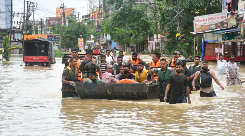
With about 28 districts of the state still reeling under flood water, the Assam State Disaster Management Authority (ASDMA), on June 24, said that there has been very marginal improvement in the overall flood situation of the state as water levels of Brahmaputra and its tributaries are receding.
Two drones have been deployed in Silchar of Cachar for carrying out the flood inundation mapping as well as to provide the relief materials in the inaccessible areas, an official of the ASDMA said.
The state authority, however, said that on Friday, the state recorded 10 deaths due to flood and landslide, taking the death toll to 118 and about 33,03,316 people in 3,510 villages under 93 revenue circles have been affected by the second wave of floods.
While two deaths were reported from Barpeta, Dhubri, Karimganj and Udalguri, one each were reported from Cachar and Morigaon districts, the ASDMA said.
The affected districts include Bajali, Baksa, Barpeta, Biswanath, Bongaigaon, Cachar, Chirang, Darrang, Dhemaji, Dhubri, Dima Hasao, Goalpara, Golaghat, Hailakandi, Hojai, Kamrup, Kamrup (M), West Karbi Anglong, Karimganj, Lakhimpur, Majuli, Morigaon, Nagaon, Nalbari, Sonitpur, South Salmara, Tamulpur and Udalguri.
Barpeta is the worst-affected district with 76,842 people of 610 villages under Barpeta, Baghbar, Barnagar, Kalgachia, Chenga and Sarthebari revenue circles have been affected by the floods, followed by Nagaon district where 5,08,475 people of 332 villages under Kamrup, Nagaon, Raha, Samaguri, Dhing and Rupa revenue circles have been affected by the floods.
Likewise, in Kamrup district, 4,01,512 of 362 villages under Rangia, Hajo, Chamaria, Chaygaon, Kamalpur, Nagarbera, Goroimari, Kayan, Palashbari and North Guwahati revenue circles have been affected by the floods.
In Cachar, a total of 2,763,45 people in 525 villages under Katigorah, Lakhipur, Silchar, Sonai and Udharbond revenue circles have been affected in the second wave.
Likewise, in Hailakandi, 27,188 of 49 villages under Katlicherra, Lala, Algapur and Hailakandi revenue circles have been affected in the second wave of floods.
In Karimganj, 2,16,411 people of 35 villages under RK Nagar, Badarpur, Nilambazar, Patherkandi and Karimganj revenue circles have been affected in the floods.
Two drones have been deployed in Silchar of Cachar for carrying out the flood inundation mapping as well as to provide the relief materials in the inaccessible areas.
Apart from that, 91,658.49 hectares of crop areas have been affected by floods in the last 24 hours. 717 relief camps and 409 relief distribution centres have been opened in the affected districts. A total of 2,65,788 people, including 69,964 children have been taking shelter in these relief camps.
Meanwhile, an expert from Gauhati University on June 24 claimed that the recent wave of flood in Assam’s Silchar town was not a natural calamity, but a disaster created by man.
“This is not a natural calamity, but a man-made flood. The dam bank has been destroyed and then videos were circulated to stake the claim of the damage,” said Dr Parag Phukan, a Professor of Geological Science at Gauhati University (GU), who is currently studying the causes and effects of floods in Silchar.
Stating that there should be a through enquiry and people responsible for this must be booked he said, “Information in the public domain shows that the Bethikandi embankment breach is a man-made one, cut by local people to drain out spill over water from the Bethikandi area back into Barak after the flood in May. This however remained unplugged making way for the monsoon surged Barak water to quickly fill the Mahisabil area that eventually had caused the deluge in Silchar.”
Questioning the authorities for failing to take up suitable measures to plug the breached embankment effectively, he said that the disaster could have been avoided, and called for an inquiry to fix accountability and address the systemic loopholes.
Dr Phukan claimed that this flood has exposed the gross inadequacy in the town planning and disaster management plan. Otherwise, how can the electricity control room and sub-stations be placed in low-lying areas prone to flooding?
“Barak water level fell from a maximum of 21.59 m to 21.45 m on Wednesday night but very slowly, still flowing more than 1.6 m above the danger level. If it remains above danger level for the next few days, water through the breached embankment at Bethukandi will further increase the inundation in Silchar,” Dr Phukan also said.
He said that flooding in Silchar town started on June 18 causing colossal damage to property and public life, with electrification and water supply also being hit across the state.
“Location of Silchar within a large loop of Barak River from Uttar Krishnapur in the upstream to Ramnagar and the highly dynamic erosion-prone nature of the river itself makes Silchar more exposed to flood hazard,” he said.
“In the current wave, data available in the public domain shows that the highest water level of Barak at Silchar was 21.59 metres on June 21 and sharing a falling trend with 21.50 metres on Thursday afternoon. Notably, the Barak basin has a total geographical area of 39000 sq km spread over the states of Manipur, Mizoram, Assam, Meghalaya and Tripura,” Phukan added.